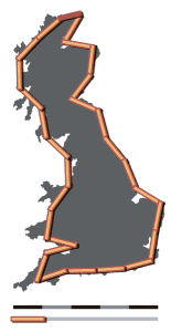
Andrew Lee writes:
I recently read in the MIT Technology Review about some researchers claiming to remove “bias” from the wisdom of crowds by focusing on those more “confident” in their views.
I [Lee] was puzzled by this result/claim because I always thought that people who (1) are more willing to reassess their priors and (2) “hedgehogs” were more accurate forecasters.
I clicked through to the article and noticed this line: “tasks such as to estimate the length of the border between Switzerland and Italy, the correct answer being 734 kilometers.”
Ha! Haven’t they ever read Mandelbrot?

Dunning-Kruger, anyone?
Ref = http://citeseerx.ist.psu.edu/viewdoc/summary?doi=10.1.1.64.2655
If you’re asking a question like “is there a restaurant which serves Shandong food?”, you get an answer from lots of crowds (Chowhound, etc.) which divide into levels of knowledge, which it seems they’re using as “confidence”. I doubt I could list all the companies working in this kind multi-level knowledge provision and collection. Which makes me wonder: who invented the +/- system for rating comments? My memory sticks on /. but I’m not particularly confident in that answer.
Ha. Unlike “natural” borders like the British one, I’d assume the Swiss/Italian one was actually set by some human beings. I don’t know what function they chose to describe the border, but unless it’s fractal there probably is a well defined length…
Florian:
I don’t know the history on this one but on the map the border looks kinda fractal. It’s not like the border between Arizona and New Mexico, that’s for sure.
> I don’t know the history on this one but on the map the border looks kinda fractal.
Not just kinda fractal, it is fractal. From what I recall of Mandelbrot, even the AZ/NM border would be fractal if you looked on a fine enough scale, e.g., grains of sand. When the border is defined by a natural feature just becomes evident on a larger (longer) scale.
I don’t know the current definition of the AZ/NM border, but originally it was defined to follow the 32nd meridian. Grains of sand didn’t come into it. Not fractal.
From Wikipedia: “…This issue was resolved when New Mexico sued Colorado in 1919, and in 1925 the Supreme Court ruled that the markers placed during the initial surveys were the actual borders, even if the markers were off in some locations (this includes the Four Corners Monument).[22] Today’s legal description of these border lines are based off the original markers, and not the written description of the borders created when the territories were formed. Because of this, the borders between these states are not perfectly straight and often zigzag. One example is the border between Colorado and Utah, where in one area the border jogs west about 1.5 miles (2.4 km) from where it was intended to be placed (along the 32nd meridian west of Washington). Because this error occurred in the original survey—which superseded the description of simply the 32nd meridian west of Washington—it remains the border between the two states.”
So the official border is defined as a finite number of straight line segments joining the original location of the survey markers. Not quite as simple as a single line, but still not fractal.
Here is he entire history of defining the border
http://www1.american.edu/ted/ice/AlpineBorder.html
I believe it’s based on natural features but is defined by humans at some level so in practice probably wouldn’t be fractal.
But sometimes the length of a border is quite well defined. In parts where US built the border fence with Mexico, its a length of the fence
The length of the border fence is not necessarily the length of the border.
Right. Researchers need to push themselves harder to do get inside the heads of respondents. The length of a mountainous border is particularly ambiguous.
Not acknowledging that borders can have lengths because of their fractal nature is like refusing to run a marathon because of Zeno’s paradox.
If the border is defined as the shortest distance between (lat1,lon1) and (lat2,lon2) then the answer is simple. If the border has a less deterministic definition then there may not be such a simple answer. How long is the English coastline? Well, it depends upon the length of the ruler you use. If you make the ruler small enough then you can get an answer that, while technically correct, is silly from a practical standpoint. (Who in their right mind would measure a coastline with a 10 nanometer ruler?) That doesn’t change the fact there are a range of reasonable answers which depend upon the length of the ruler you choose. Claiming that there’s a precise answer to the question, “How long is the English coastline?” doesn’t hold up to scrutiny. It depends upon how you make the measurement.
Wikipedia has a table of Border lengths of nations. The CIA factbook lists them too. The numbers agree for most part. What definitions are they using?
My only point is that asking how long the land border of a nation is may not be as absurd a question as some comments (and Andrew?) seem to imply. Most people seem to intuitively / implicitly agree upon the nature of ruler used. Not everyone is confused by the possibility of nanometer rulers.
Fiddly Bits would have been a good title.